
Policy information sourced from the Barking & Dagenham Local Plan
SPP3 Dagenham Dock and Freeport
11.
Within the Dagenham Dock and Freepor t Policy Area as identified on the Policies Map, there is indicative capacity for 7,240 new homes and approximately 776,852 sq.m additional industrial floor space in the Plan period. Buildings up to 50 metres in height could be appropriate in this area.
12.
This policy allocates the following sites as identified on the Policies Map (with fur ther details and requirements for individual sites available in the site proformas in Appendix 2 and in the Housing Trajectory in Appendix 4):
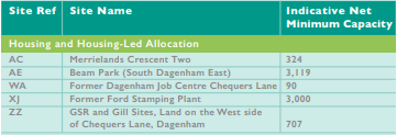
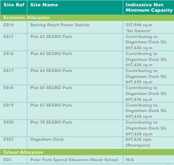
Dagenham Dock Transformation Area (as shown on the Policies Map)
13.
To deliver our vision, development proposals should be consistent with the followng principles:
- enable redevelopment of the area, incorporating sustainable and green industries and building on the location’s logistics, food and energy operations
- capitalise on the extensive road, rail and river infrastructure connections, which provide national and international connections, including a rail hub as par t of the proposed Freeport
- enable the expansion and intensification of employment floor space enabling wider regeneration oppor tunities for the Thames Freeport in Dagenham (also see below)
- have full regard to the consented scheme at Barking River side and to engage with Barking Riverside Limited in the common interest of securing the benefits and comprehensive regeneration of London River side and Strategic Opportunity Area (e.g., through attending the existing Barking Riverside Steering Group)
- align with plans for the successful relocation and co-location of London’s three wholesale city markets – Billingsgate, Smithfield and New Spitalfields, enabling development that will support its operation within the borough
- enhance the development of existing rail, maritime and river transpor t infrastr ucture to be utilised within the wider area and the Thames Estuary as a whole
- deliver a new secondary school to the north of the area, at the Ford Stamping Plant site; and a new primary school at the GSR & Gill site
- strengthening links to Dagenham Dock Station with a clear hierarchy of movement routes through the site up to New Road. There will be a strong focus on improved visual connections, including new bus cycle walking links incorporating enhanced green infrastructure
- improve connectivity along Chequers Lane and Kent Avenue to improve access along and between the Freeport and the City Markets
Thames Freeport in Dagenham
14.
Development of an open access international intermodal rail terminal will be suppor ted and any development proposals on the Ford site will need to demonstrate they do not prejudice the potential for delivery of such a rail terminal. Beam Park Transformation Area (as shown on the Policies Map)
15.
The Council will continue to support the comprehensive redevelopment of Beam Park by working collaboratively with the Greater London Authority, London Borough of Havering and other stakeholders to support development that contributes to the delivery of a thriving, mixed-use residential neighbourhood suppor ted by health, education and other community infrastructure in line with the Council’s latest Infrastructure Delivery Plan. The Council will support development that delivers:
- new affordable family homes with low rise housing terraces
- two new primary schools and a new medical centre
- a station square to provide a new retail and commercial focus to the area, integrated with the planned new transport interchange – Beam Park Station
- new park and community meeting spaces in an open space and parkland setting to form a natural meeting place for the neighbourhood
- new hierarchy of routes for safe connections within and between neighbourhoods
- a landscape identity that creates clear wayfinding links to and from the park; visible verdant environments that can double for amenity and ecological value
- a green corridor providing a pedestrian connection to the station and enhancements to the pedestrian and cycle network across the area
- a strengthened relationship with adjacent land/areas, including Dagenham Dock and Castle Green Transformation Areas and Merrielands Crescent
- flood mitigation and adaptation measures to comply with Policies DME4 and DMSI 6.
Ford Stamping Plant
16.
The Council will support development in this location which:
- provides a comprehensive residential-led mixed-use development including flexible community and commercial floor space
- provides new supportive social infrastructure including a 10-form intake secondar y school, cultural facilities and open space
- creates a coherent townscape which responds positively to its existing and emerging context, including amenity space and improved public realm
- assists the integration of improved public transport links including new accessible bus stops and improved accessibility to Dagenham Dock station
- creates an improved walking environment to allow access to employment sites, retail hubs and the proposed secondary school.
Merrielands
17.
The Council will support development in this location which:
- strengthens the relationship with adjacent land/areas including Merrielands Crescent One and the Transformation Areas at Beam Park and Dagenham Dock (as shown on the Policies Map)
- provides flood mitigation and adaptation measures in line with Policies DMNE4 and DMSI6
- promotes sustainable modes of transport and incorporates car free and car lite principles.
GSR and Gill Sites
18.
The Council will support development in this location which:
- delivers outstanding design and makes a positive contribution to the local character and neighbourhood
- improves links with the site to the north and Stamping Plant and new public realm and accessibility to the station to the south as well as the roads to the north and west
- delivers improvements to the overall quality of the greenway
- through the scale and massing of development should contribute to the creation of a new coherent townscape which responds positively to its existing and emerging context
- seeks to minimise car parking in the location with the delivery of car lite and car free developments in line with Policy DMT 2.
For more information please see the Barking & Dagenham Local Plan